一、问题背景与核心需求
在Cesium 河流实现中,开发者常遇到以下问题:
- 河流材质显示异常,预设蓝色却显示为白色
- 河流线条生硬,缺乏自然流动感
- 交互功能单一,无法动态调整视觉效果
- 地图切换时河流元素兼容性差
针对这些问题,我们需要构建一个具备以下功能的解决方案:
- 稳定显示自定义颜色的河流材质
- 支持多种地图底图切换
- 提供河流颜色选择功能
- 实现河流数量统计与管理
- 优化加载体验与交互反馈
二、技术方案设计
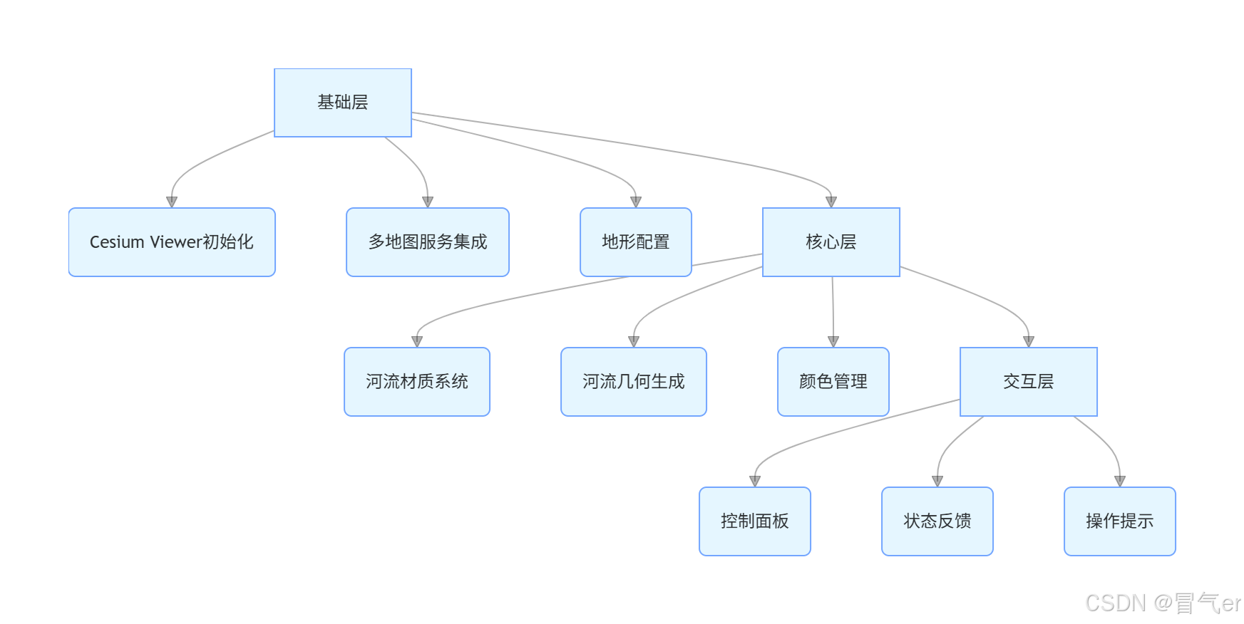
2.1 整体架构设计
本方案采用三层架构设计:
- 基础层:Cesium Viewer 初始化与地图服务配置
- 核心层:河流材质系统与几何生成
- 交互层:控制面板与用户反馈系统
2.2 关键技术点解析
2.2.1 Cesium Viewer 初始化优化
为解决地图加载速度与稳定性问题,我们采用以下配置:
viewer = new Cesium.Viewer('cesium-container', {
    // 默认使用OpenStreetMap
    imageryProvider: new Cesium.OpenStreetMapImageryProvider({
        url: 'https://a.tile.openstreetmap.org/'
    }),
    // 使用简单地形提升性能
    terrainProvider: new Cesium.EllipsoidTerrainProvider(),
    // 精简不必要控件
    baseLayerPicker: false,
    geocoder: false,
    homeButton: true,
    sceneModePicker: true,
    timeline: false,
    animation: false,
    navigationHelpButton: false,
    fullscreenButton: true,
    infoBox: false
});
优化点:
- 移除不必要的 UI 控件,提升加载速度
- 使用公开的 OSM 地图服务,无需 API 密钥
- 采用轻量级地形 provider,平衡性能与效果
2.2.2 河流材质问题修复核心代码
这是解决河流显示为白色问题的关键部分,我们采用PolylineOutlineMaterialProperty替代基础颜色材质:
// 修复后的河流材质实现
const riverMaterial = new Cesium.PolylineOutlineMaterialProperty({
    color: currentRiverColor.withAlpha(0.8),  // 主颜色,带透明度
    outlineColor: Cesium.Color.BLACK.withAlpha(0.3),  // 轮廓色,增强层次感
    outlineWidth: 1  // 轮廓宽度
});

// 河流实体配置
const river = viewer.entities.add({
    name: '河流 ' + (riverCount + 1),
    polyline: {
        positions: riverPoints,  // 河流路径点
        width: 15 + (riverCount * 2),  // 宽度,每条河流递增
        material: riverMaterial,  // 使用修复后的材质
        clampToGround: true  // 贴地显示
    },
    description: '这是模拟河流 #' + (riverCount + 1)
});
修复原理:
- 使用带轮廓的材质替代单一颜色材质,增强视觉层次
- 明确设置透明度,避免颜色叠加导致的显示异常
- 添加黑色轮廓,使河流在不同底图上都能清晰显示
- 启用
clampToGround确保河流贴合地形
2.2.3 多地图服务集成
实现三种常用地图服务的切换功能:
function changeMapType(type) {
    try {
        viewer.imageryLayers.removeAll();  // 清除现有图层

        switch (type) {
            case 'osm':
                // OpenStreetMap 矢量地图
                viewer.imageryLayers.addImageryProvider(new Cesium.OpenStreetMapImageryProvider({
                    url: 'https://a.tile.openstreetmap.org/'
                }));
                break;
            case 'arcgis':
                // ArcGIS 卫星影像
                viewer.imageryLayers.addImageryProvider(new Cesium.ArcGisMapServerImageryProvider({
                    url: 'https://services.arcgisonline.com/ArcGIS/rest/services/World_Imagery/MapServer'
                }));
                break;
            case 'stamen':
                // Stamen 地形图
                viewer.imageryLayers.addImageryProvider(new Cesium.OpenStreetMapImageryProvider({
                    url: 'https://stamen-tiles.a.ssl.fastly.net/terrain/'
                }));
                break;
        }
    } catch (error) {
        // 错误处理
    }
}
三、完整实现代码
以下是包含所有功能的完整代码,可直接复制使用:
<!DOCTYPE html>
<html lang="zh-CN">
<head>
<meta charset="UTF-8">
<meta name="viewport" content="width=device-width, initial-scale=1.0">
<title>Cesium河流效果 - 修复材质问题</title>
<script src="https://cesium.com/downloads/cesiumjs/releases/1.95/Build/Cesium/Cesium.js"></script>
<link href="https://cesium.com/downloads/cesiumjs/releases/1.95/Build/Cesium/Widgets/widgets.css" rel="stylesheet">
<style>
body {
margin: 0;
padding: 0;
font-family: 'Microsoft YaHei', 'Segoe UI', Tahoma, Geneva, Verdana, sans-serif;
background: #1a1a1a;
overflow: hidden;
}
#cesium-container {
width: 100%;
height: 100vh;
}
.control-panel {
position: absolute;
top: 20px;
left: 20px;
background: rgba(42, 42, 42, 0.95);
padding: 20px;
border-radius: 10px;
color: white;
z-index: 1000;
max-width: 320px;
box-shadow: 0 4px 15px rgba(0, 0, 0, 0.5);
backdrop-filter: blur(10px);
border: 1px solid #4CAF50;
}
h2 {
margin-top: 0;
color: #4CAF50;
border-bottom: 2px solid #4CAF50;
padding-bottom: 10px;
text-align: center;
}
.button-group {
display: flex;
gap: 10px;
margin-top: 15px;
}
button {
background: linear-gradient(to bottom, #4CAF50, #367c39);
border: none;
color: white;
padding: 12px 15px;
border-radius: 5px;
cursor: pointer;
flex: 1;
font-weight: bold;
transition: all 0.3s;
}
button:hover {
background: linear-gradient(to bottom, #367c39, #2a5c2c);
transform: translateY(-2px);
box-shadow: 0 4px 8px rgba(0, 0, 0, 0.3);
}
button.secondary {
background: linear-gradient(to bottom, #607D8B, #455A64);
}
button.secondary:hover {
background: linear-gradient(to bottom, #455A64, #37474F);
}
.info {
background: rgba(30, 30, 30, 0.8);
padding: 15px;
border-radius: 8px;
margin-top: 15px;
font-size: 14px;
line-height: 1.5;
}
.river-info {
display: flex;
justify-content: space-between;
margin-top: 10px;
padding: 10px;
background: rgba(50, 50, 50, 0.7);
border-radius: 5px;
font-weight: bold;
}
.logo {
text-align: center;
margin-bottom: 15px;
font-size: 24px;
font-weight: bold;
color: #4CAF50;
}
.loading {
position: absolute;
top: 50%;
left: 50%;
transform: translate(-50%, -50%);
color: white;
font-size: 20px;
z-index: 1000;
background: rgba(0, 0, 0, 0.8);
padding: 20px 30px;
border-radius: 10px;
text-align: center;
}
.map-type-selector {
margin-top: 15px;
}
select {
width: 100%;
padding: 10px;
border-radius: 5px;
background: #2d2d2d;
color: white;
border: 1px solid #4CAF50;
margin-top: 5px;
}
.status {
margin-top: 10px;
padding: 8px;
background: rgba(50, 50, 50, 0.7);
border-radius: 5px;
font-size: 12px;
text-align: center;
}
.color-picker {
margin-top: 10px;
}
.color-option {
display: inline-block;
width: 20px;
height: 20px;
border-radius: 50%;
margin: 5px;
cursor: pointer;
border: 2px solid transparent;
}
.color-option.active {
border-color: white;
}
</style>
</head>
<body>
<div id="cesium-container"></div>
<div id="loading" class="loading">正在加载地图和河流效果...</div>
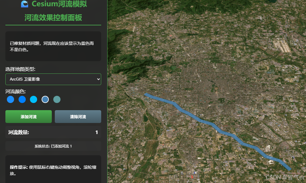
<div class="control-panel">
<div class="logo">🌊 Cesium河流模拟</div>
<h2>河流效果控制面板</h2>
<div class="info">
<p>已修复材质问题,河流现在应该显示为蓝色而不是白色。</p>
</div>
<div class="map-type-selector">
<label>选择地图类型:</label>
<select id="map-type">
<option value="osm">OpenStreetMap (默认)</option>
<option value="arcgis">ArcGIS 卫星影像</option>
<option value="stamen">Stamen 地形图</option>
</select>
</div>
<div class="color-picker">
<label>河流颜色:</label>
<div>
<span class="color-option active" style="background:#1E90FF;"
onclick="changeRiverColor('#1E90FF')"></span>
<span class="color-option" style="background:#0080FF;" onclick="changeRiverColor('#0080FF')"></span>
<span class="color-option" style="background:#00BFFF;" onclick="changeRiverColor('#00BFFF')"></span>
<span class="color-option" style="background:#4682B4;" onclick="changeRiverColor('#4682B4')"></span>
<span class="color-option" style="background:#5F9EA0;" onclick="changeRiverColor('#5F9EA0')"></span>
</div>
</div>
<div class="button-group">
<button onclick="addRiverEffect()">添加河流</button>
<button onclick="clearAllRivers()" class="secondary">清除河流</button>
</div>
<div class="river-info">
<span>河流数量:</span>
<span id="river-count">0</span>
</div>
<div class="status" id="status">
系统状态: 正常
</div>
<div class="info">
<p><strong>操作提示:</strong> 使用鼠标右键拖动调整视角,滚轮缩放。</p>
</div>
</div>
<script>
// 初始化Cesium Viewer - 使用无需令牌的公开地图服务
let viewer;
let currentRiverColor = Cesium.Color.fromCssColorString('#1E90FF');
try {
viewer = new Cesium.Viewer('cesium-container', {
// 默认使用OpenStreetMap
imageryProvider: new Cesium.OpenStreetMapImageryProvider({
url: 'https://a.tile.openstreetmap.org/'
}),
// 使用简单地形
terrainProvider: new Cesium.EllipsoidTerrainProvider(),
baseLayerPicker: false,
geocoder: false,
homeButton: true,
sceneModePicker: true,
timeline: false,
animation: false,
navigationHelpButton: false,
fullscreenButton: true,
infoBox: false
});
// 设置初始视角 - 中国北京附近
viewer.camera.setView({
destination: Cesium.Cartesian3.fromDegrees(116.3, 39.85, 8000),
orientation: {
heading: 0,
pitch: -0.8,
roll: 0
}
});
// 监听地图类型变化
document.getElementById('map-type').addEventListener('change', function () {
changeMapType(this.value);
});
} catch (error) {
document.getElementById('status').textContent = '系统状态: 错误 - ' + error.message;
document.getElementById('status').style.background = 'rgba(200, 50, 50, 0.7)';
}
// 河流计数器
let riverCount = 0;
// 更改地图类型
function changeMapType(type) {
try {
viewer.imageryLayers.removeAll();
switch (type) {
case 'osm':
viewer.imageryLayers.addImageryProvider(new Cesium.OpenStreetMapImageryProvider({
url: 'https://a.tile.openstreetmap.org/'
}));
showMessage('已切换到OpenStreetMap');
break;
case 'arcgis':
viewer.imageryLayers.addImageryProvider(new Cesium.ArcGisMapServerImageryProvider({
url: 'https://services.arcgisonline.com/ArcGIS/rest/services/World_Imagery/MapServer'
}));
showMessage('已切换到ArcGIS卫星影像');
break;
case 'stamen':
viewer.imageryLayers.addImageryProvider(new Cesium.OpenStreetMapImageryProvider({
url: 'https://stamen-tiles.a.ssl.fastly.net/terrain/'
}));
showMessage('已切换到Stamen地形图');
break;
}
document.getElementById('status').textContent = '系统状态: 已切换地图类型';
} catch (error) {
document.getElementById('status').textContent = '系统状态: 切换地图失败';
}
}
// 更改河流颜色
function changeRiverColor(colorHex) {
currentRiverColor = Cesium.Color.fromCssColorString(colorHex);
// 更新所有活动颜色选择器
document.querySelectorAll('.color-option').forEach(option => {
option.classList.remove('active');
});
event.target.classList.add('active');
showMessage('已选择新颜色: ' + colorHex);
}
// 显示消息
function showMessage(message) {
const entity = viewer.entities.add({
position: Cesium.Cartesian3.fromDegrees(116.3, 40.0, 0),
label: {
text: message,
font: '16px Microsoft YaHei',
pixelOffset: new Cesium.Cartesian2(0, 50),
fillColor: Cesium.Color.GREEN,
outlineColor: Cesium.Color.BLACK,
outlineWidth: 2,
style: Cesium.LabelStyle.FILL_AND_OUTLINE,
heightReference: Cesium.HeightReference.CLAMP_TO_GROUND,
showBackground: true,
backgroundColor: new Cesium.Color(0.2, 0.2, 0.2, 0.7)
}
});
// 3秒后移除消息
setTimeout(() => {
viewer.entities.remove(entity);
}, 3000);
}
// 更新河流计数
function updateRiverCount() {
document.getElementById('river-count').textContent = riverCount;
}
// 清除所有河流
function clearAllRivers() {
viewer.entities.removeAll();
riverCount = 0;
updateRiverCount();
showMessage('所有河流已清除');
document.getElementById('status').textContent = '系统状态: 已清除所有河流';
}
// 河流效果函数 - 修复材质问题
function addRiverEffect() {
try {
// 河流坐标点 - 更自然的曲线
const riverPoints = [
Cesium.Cartesian3.fromDegrees(116.2, 39.9, 0),
Cesium.Cartesian3.fromDegrees(116.22, 39.89, 0),
Cesium.Cartesian3.fromDegrees(116.25, 39.88, 0),
Cesium.Cartesian3.fromDegrees(116.28, 39.87, 0),
Cesium.Cartesian3.fromDegrees(116.3, 39.85, 0),
Cesium.Cartesian3.fromDegrees(116.32, 39.84, 0),
Cesium.Cartesian3.fromDegrees(116.35, 39.82, 0),
Cesium.Cartesian3.fromDegrees(116.38, 39.81, 0),
Cesium.Cartesian3.fromDegrees(116.4, 39.79, 0),
Cesium.Cartesian3.fromDegrees(116.43, 39.78, 0),
Cesium.Cartesian3.fromDegrees(116.45, 39.76, 0),
Cesium.Cartesian3.fromDegrees(116.48, 39.75, 0),
Cesium.Cartesian3.fromDegrees(116.5, 39.73, 0),
Cesium.Cartesian3.fromDegrees(116.53, 39.72, 0),
Cesium.Cartesian3.fromDegrees(116.55, 39.7, 0),
];
// 方法1:使用简单的颜色材质(确保颜色正确)
const riverMaterial = new Cesium.ColorMaterialProperty(currentRiverColor.withAlpha(0.7));
// 方法2:使用PolylineOutlineMaterialProperty获得更好的视觉效果
// const riverMaterial = new Cesium.PolylineOutlineMaterialProperty({
// color: currentRiverColor.withAlpha(0.8),
// outlineColor: Cesium.Color.BLACK.withAlpha(0.3),
// outlineWidth: 1
// });
// 添加河流实体
const river = viewer.entities.add({
name: '河流 ' + (riverCount + 1),
polyline: {
positions: riverPoints,
width: 15 + (riverCount * 2),
material: riverMaterial,
clampToGround: true
},
description: '这是模拟河流 #' + (riverCount + 1)
});
riverCount++;
updateRiverCount();
// 定位到河流
viewer.zoomTo(river);
showMessage('河流 ' + riverCount + ' 已添加');
document.getElementById('status').textContent = '系统状态: 已添加河流 ' + riverCount;
} catch (error) {
document.getElementById('status').textContent = '系统状态: 添加河流失败 - ' + error.message;
document.getElementById('status').style.background = 'rgba(200, 50, 50, 0.7)';
}
}
// 初始更新计数
updateRiverCount();
// 添加初始河流
setTimeout(() => {
addRiverEffect();
document.getElementById('loading').style.display = 'none';
document.getElementById('status').textContent = '系统状态: 初始化完成';
}, 1500);
</script>
</body>
</html>